0

Out-of-universe map showing ten years of building Diarcesia's administrative divisions and neighbors. Ask me anything!

preview

Context: Diarcesia is a fictional nation project started on 2016 in the NationStates website with this premise — starting with a Greco-Roman cultural concept and deferring details until you need it/are sufficiently inspired, how far can you go?

Ten years later, as shown in this map, I still have quite a bit to go, but I have also gone far since I began. A lot of what I’ve canonized wouldn’t have been possible if I decided to flesh concepts out at the beginning.

Lastly, ask me anything! I’m particularly interested if you’re able to spot the inspirations or references in the map!

Another entry in the same universe: the Nankrai Archipelago

Co-op Credits

Andrenade - Neraserria (land of the Nerra)

Delmonte - Dionysia (island leased to Delmonte)

Context: Diarcesia is a fictional nation project started on 2016 in the NationStates website with this premise — starting with a Greco-Roman cultural concept and deferring details until you need it/are sufficiently inspired, how far can you go?

Ten years later, as shown in this map, I still have quite a bit to go, but I have also gone far since I began. A lot of what I’ve canonized wouldn’t have been possible if I decided to flesh concepts out at the beginning.

Lastly, ask me anything! I’m particularly interested if you’re able to spot the inspirations or references in the map!

Another entry in the same universe: the Nankrai Archipelago

Co-op Credits

Andrenade - Neraserria (land of the Nerra)

Delmonte - Dionysia (island leased to Delmonte)

0

People who make alt-history maps: what's your process?

preview

I’ve made a fair few entirely fictional maps and I have a process I’m quite happy with. I have much less experience on working with maps of the real world. A bit of alt history writing has captured my attention lately and I’d like to put visuals to it eventually, so I’d better figure that out. How do you go about it for your projects?

I’ve made a fair few entirely fictional maps and I have a process I’m quite happy with. I have much less experience on working with maps of the real world. A bit of alt history writing has captured my attention lately and I’d like to put visuals to it eventually, so I’d better figure that out. How do you go about it for your projects?

0

Professional Cartographer maps out the planet of Sid Meier’s Alpha Centauri and its moon.

Professional Cartographer maps out the planet of Sid Meier’s Alpha Centauri and its moon.
preview

Cross-posted from “Professional Cartographer maps out the planet of Sid Meier’s Alpha Centauri and its moon.” by @Agent_Karyo@piefed.world in !space_games@piefed.world


Source: somethingaboutmaps.wordpress.com/…/planetfall/

Thanks to civfanatics on Mastadon .

Cross-posted from “Professional Cartographer maps out the planet of Sid Meier’s Alpha Centauri and its moon.” by @Agent_Karyo@piefed.world in !space_games@piefed.world


Source: somethingaboutmaps.wordpress.com/…/planetfall/

Thanks to civfanatics on Mastadon .

0

City of Anstice (by Maxime Plasse)

preview

From: www.deviantart.com/…/City-of-Anstice-459658201

“This map was commisioned by the writer Matt Karlov for his upcoming book “The Unbound Man”. This is the second piece of a 3-maps set. It’s digitally hand-drawn in Photoshop and its size is 5x8” (2 versions provided, one sepia tone and one greyscale) © 2014 - all rights reserved"

From: www.deviantart.com/…/City-of-Anstice-459658201

“This map was commisioned by the writer Matt Karlov for his upcoming book “The Unbound Man”. This is the second piece of a 3-maps set. It’s digitally hand-drawn in Photoshop and its size is 5x8” (2 versions provided, one sepia tone and one greyscale) © 2014 - all rights reserved"

0

Nankrai Archipelago (2023)

preview

Diarcesia is a supranational monarchy (as in ruled by a leader titled “Monarch”) in a fictional planet which allowed its component country (called a “dieresis”) to secede. Diarcesia used to hold considerable influence in the Nankrai Archipelago and once held large parts of Rhozerus and Yechia.

In 1872, Mervin, the last of the expansionist Monarchs was deposed and killed. His successor, Grere, passed democratic reforms that included the end of expansionist wars. Many of the less-willing diereses—mostly overseas and a few in the mainland—seceded without incident. These included the Diarcesian holdings of the Nankrai Archipelago outside Ikuyo, which remained loyal.

That loyalty was to be tested in 2028 when disgruntled elements northern half (“Kita Ikuyo”) launched a surprise attack in Kaisura in its bid to free itself from Ikuyo dieresis and Diarcesia as a whole. The event came to be known as the Cutting of Kaisura.

Diarcesia is a supranational monarchy (as in ruled by a leader titled “Monarch”) in a fictional planet which allowed its component country (called a “dieresis”) to secede. Diarcesia used to hold considerable influence in the Nankrai Archipelago and once held large parts of Rhozerus and Yechia.

In 1872, Mervin, the last of the expansionist Monarchs was deposed and killed. His successor, Grere, passed democratic reforms that included the end of expansionist wars. Many of the less-willing diereses—mostly overseas and a few in the mainland—seceded without incident. These included the Diarcesian holdings of the Nankrai Archipelago outside Ikuyo, which remained loyal.

That loyalty was to be tested in 2028 when disgruntled elements northern half (“Kita Ikuyo”) launched a surprise attack in Kaisura in its bid to free itself from Ikuyo dieresis and Diarcesia as a whole. The event came to be known as the Cutting of Kaisura.

0

Fictional Metro Map of Déplenne

preview

This map depicts the metro system of Déplenne, the second largest city of a fictional version of North America with the former Dutch colonies surviving and thriving, leading to a more Dutch America.

This map depicts the metro system of Déplenne, the second largest city of a fictional version of North America with the former Dutch colonies surviving and thriving, leading to a more Dutch America.

0

Ara Zva, a large island I created for a TTRPG campaign

preview

And a “satellite” view of the same https://i.imgur.com/YyF3JPJ.jpeg

This was made with a combination of Inkscape, Gimp, and a janky but delightful erosion-simulation tool called Wilbur http://www.fracterra.com/wilbur.html

And a “satellite” view of the same https://i.imgur.com/YyF3JPJ.jpeg

This was made with a combination of Inkscape, Gimp, and a janky but delightful erosion-simulation tool called Wilbur http://www.fracterra.com/wilbur.html

0

Jerry's Map - an art project to draw and update a map as the random cards direct

Jerry's Map Jerry's Map www.jerrysmap.com
preview

Jerry Gretzinger has been drawing and updating this map one panel at a time based on random card draws. Over the decades his style and art interests have changed and that’s reflected in the map.

I bought a few panels and I love them. I’ve been aware of the project for years and years. I would love to see it in an exhibition somewhere.

Jerry Gretzinger has been drawing and updating this map one panel at a time based on random card draws. Over the decades his style and art interests have changed and that’s reflected in the map.

I bought a few panels and I love them. I’ve been aware of the project for years and years. I would love to see it in an exhibition somewhere.

0

City of Wisburg

preview

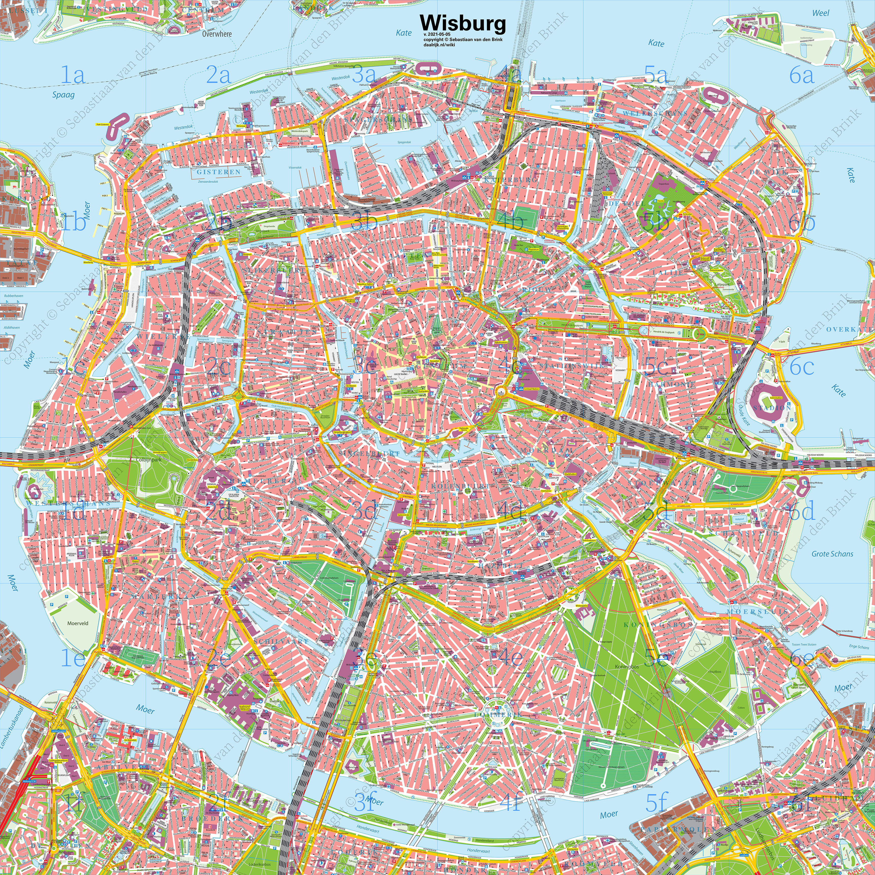
This is a massive city map (that I am currently reworking and making even larger) of Wisburg. A fictional Dutch-style city of over 2 million people. This is just the city center, mind you. It has over 2000 unique streetnames.

This is a massive city map (that I am currently reworking and making even larger) of Wisburg. A fictional Dutch-style city of over 2 million people. This is just the city center, mind you. It has over 2000 unique streetnames.

0

A wonderful stylized version of the Middle Earth map

preview

cross-posted from: hobbit.world/post/7613

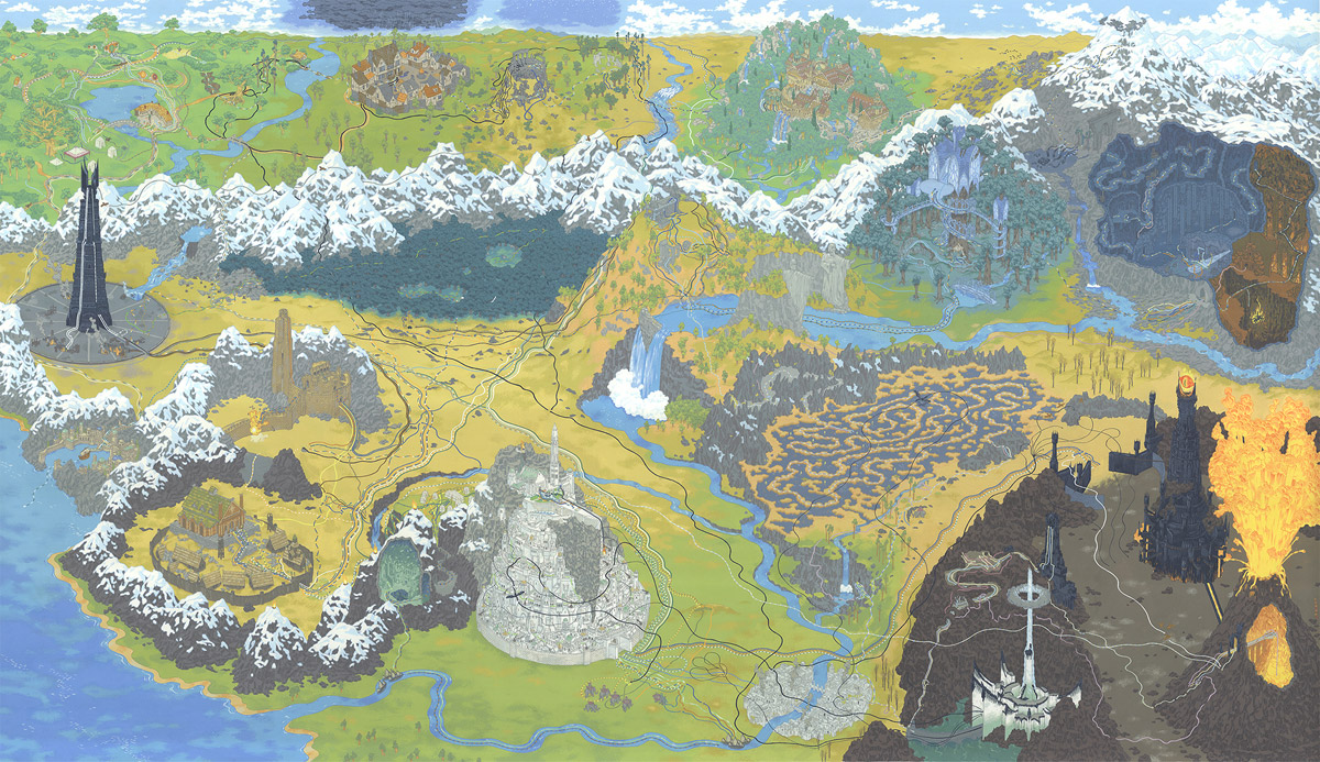
This is a wonderful stylized version of the Middle Earth map which shows the path of the ring, although you need to zoom in to see all those lines. The orientation of things is kind of all over the place, but that was obviously done in order to fit all the different places into a single image. I wouldn’t use it to actually travel in Middle Earth, but it looks amazing.

Minas Tirith and Mordor are positioned side by side like normal in the front, but behind we actually see things going westward with Isengaard in the middle left. Then Hobbiton, Bree, Weathertop, Rivendell, Lorien, and Moria along the top left to right. I won’t list every place in there, but they managed to cram practically everything in there.

I wanted to link to the gif of the making of this image, but Lemmy didn’t like it. But, I strongly recommend checking it out. I love seeing the stages of art being made.

Also, check out all the details about this image by Andrew DeGraff. It shows lots of detail about different parts of this image.

cross-posted from: hobbit.world/post/7613

This is a wonderful stylized version of the Middle Earth map which shows the path of the ring, although you need to zoom in to see all those lines. The orientation of things is kind of all over the place, but that was obviously done in order to fit all the different places into a single image. I wouldn’t use it to actually travel in Middle Earth, but it looks amazing.

Minas Tirith and Mordor are positioned side by side like normal in the front, but behind we actually see things going westward with Isengaard in the middle left. Then Hobbiton, Bree, Weathertop, Rivendell, Lorien, and Moria along the top left to right. I won’t list every place in there, but they managed to cram practically everything in there.

I wanted to link to the gif of the making of this image, but Lemmy didn’t like it. But, I strongly recommend checking it out. I love seeing the stages of art being made.

Also, check out all the details about this image by Andrew DeGraff. It shows lots of detail about different parts of this image.