When the Swedish warship Vasa sank in Stockholm harbor in August 1628 it was basically a massive failure of naval infrastructure. King Gustav II Adolf commissioned it as a flagship but it was built far too narrow and top heavy for the amount of carved wooden propaganda attached to the hull. It rolled over and went down barely 1300 meters into its maiden voyage.
Vasa historically vital is what the local geography did to the physical hardware. In standard open ocean water wood boring shipworms will consume an oak hull within a few decades. But the Baltic Sea has restricted saltwater inflow and massive freshwater river runoff. The salinity drops too low for the mollusks to survive.
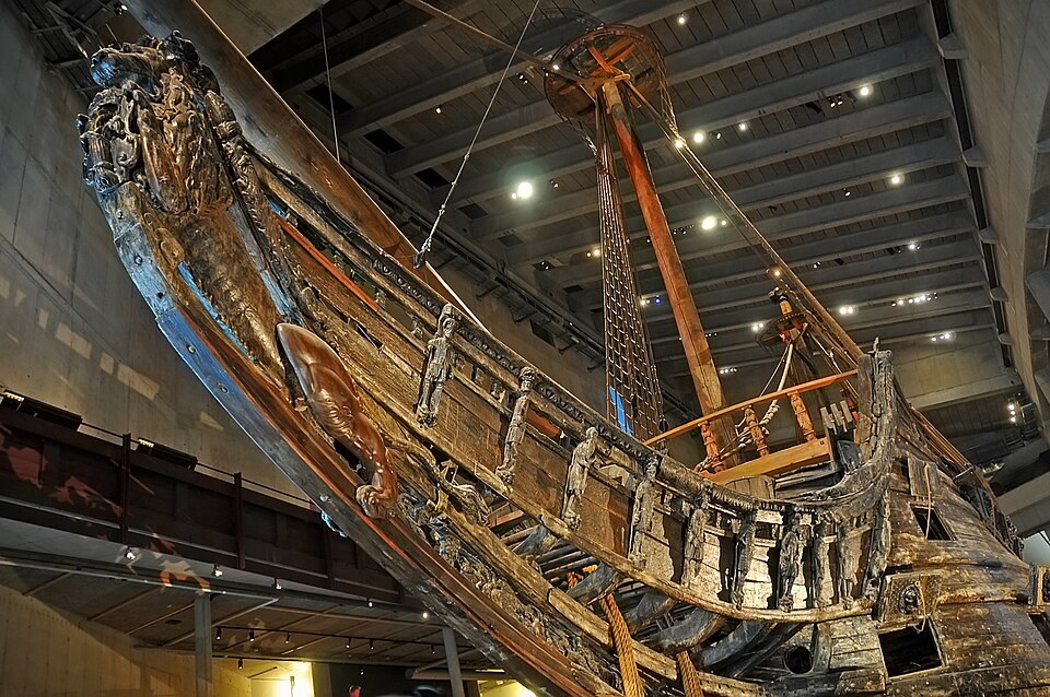
water chemistry essentially acted as a geographic preservation vault. When salvage crews raised the hull in 1961 this two tonne carved oak lion figurehead was almost entirely intact. It proves that a wrecks specific chemical environment does just as much work as human effort in deciding what historical hardware survives.
When the Swedish warship Vasa sank in Stockholm harbor in August 1628 it was basically a massive failure of naval infrastructure. King Gustav II Adolf commissioned it as a flagship but it was built far too narrow and top heavy for the amount of carved wooden propaganda attached to the hull. It rolled over and went down barely 1300 meters into its maiden voyage.
Vasa historically vital is what the local geography did to the physical hardware. In standard open ocean water wood boring shipworms will consume an oak hull within a few decades. But the Baltic Sea has restricted saltwater inflow and massive freshwater river runoff. The salinity drops too low for the mollusks to survive.
water chemistry essentially acted as a geographic preservation vault. When salvage crews raised the hull in 1961 this two tonne carved oak lion figurehead was almost entirely intact. It proves that a wrecks specific chemical environment does just as much work as human effort in deciding what historical hardware survives.
do u study Gilded Age architecture for the surface aesthetics but the subterranean infrastructure is much more telling. The ultra wealthy in late 19th century New York installed a massive underground legacy system. They dug private brick tunnels and basement rail networks connecting carriage houses directly into the mansion cellars. It was basically institutional firmware designed to erase the working staff from sight. I tracked down the original blueprints and property logs.
do u study Gilded Age architecture for the surface aesthetics but the subterranean infrastructure is much more telling. The ultra wealthy in late 19th century New York installed a massive underground legacy system. They dug private brick tunnels and basement rail networks connecting carriage houses directly into the mansion cellars. It was basically institutional firmware designed to erase the working staff from sight. I tracked down the original blueprints and property logs.
When reviewing major archaeological discoveries from the past century, what stands out is how often a single physical archive forces historians to completely redraw their working models of antiquity.
Royal Archives of Ebla (Tell Mardikh, Syria): Before excavators uncovered Royal Palace G in the 1970s, standard historiography modeled the Bronze Age Near East as a strict trade duopoly between Egypt and Mesopotamia. Finding over 1,800 intact cuneiform tablets proved an autonomous, highly organized commercial power existed across the Levant.
Uluburun Shipwreck (Kaş, Turkey): Sinking around 1305 BCE with raw cargo sourced from Cyprus, Central Asia, the Baltic, Nubia, and Mycenae, this single vessel provided direct physical proof that the Late Bronze Age Mediterranean operated as an integrated, circular international market.
sanxingdui (Sichuan, China The 1986 discovery of massive sacrificial pits containing colossal bronze masks broke the long-held “Yellow River hypothesis,” showing that complex urban metallurgy developed simultaneously across separate river basins.
When reviewing major archaeological discoveries from the past century, what stands out is how often a single physical archive forces historians to completely redraw their working models of antiquity.
Royal Archives of Ebla (Tell Mardikh, Syria): Before excavators uncovered Royal Palace G in the 1970s, standard historiography modeled the Bronze Age Near East as a strict trade duopoly between Egypt and Mesopotamia. Finding over 1,800 intact cuneiform tablets proved an autonomous, highly organized commercial power existed across the Levant.
Uluburun Shipwreck (Kaş, Turkey): Sinking around 1305 BCE with raw cargo sourced from Cyprus, Central Asia, the Baltic, Nubia, and Mycenae, this single vessel provided direct physical proof that the Late Bronze Age Mediterranean operated as an integrated, circular international market.
sanxingdui (Sichuan, China The 1986 discovery of massive sacrificial pits containing colossal bronze masks broke the long-held “Yellow River hypothesis,” showing that complex urban metallurgy developed simultaneously across separate river basins.
In the early 1920s, the US Postal Service faced a major bottleneck: airmail was fast by day, but cross-country routes stalled at sunset because pilots had no reliable navigation instruments for night flights or fog.
so to solve this, government constructed the Transcontinental Airway System a physical visual highway stretching from New York to San Francisco 50 foot concrete arrows: Poured directly into the ground and painted bright chrome yellow to point pilots along the exact flight corridor.
Rotating gas beacons: Placed atop 50-foot steel skeletal towers mounted at the center of each arrow, flashing distinctive Morse codes every 10 miles.
Small concrete shacks housing automated generators and fuel supplies stood at the tail of each arrow.
Pilots would fly from one flashing beacon to the next, checking the physical orientation of the arrow beneath them to stay on course. Within a decade, radio navigation and radar rendered the visual airway obsolete, leading to the decommission of the towers. However, hundreds of these massive concrete arrows remain preserved on remote hillsides and desert terrain across the American West today.
In the early 1920s, the US Postal Service faced a major bottleneck: airmail was fast by day, but cross-country routes stalled at sunset because pilots had no reliable navigation instruments for night flights or fog.
so to solve this, government constructed the Transcontinental Airway System a physical visual highway stretching from New York to San Francisco 50 foot concrete arrows: Poured directly into the ground and painted bright chrome yellow to point pilots along the exact flight corridor.
Rotating gas beacons: Placed atop 50-foot steel skeletal towers mounted at the center of each arrow, flashing distinctive Morse codes every 10 miles.
Small concrete shacks housing automated generators and fuel supplies stood at the tail of each arrow.
Pilots would fly from one flashing beacon to the next, checking the physical orientation of the arrow beneath them to stay on course. Within a decade, radio navigation and radar rendered the visual airway obsolete, leading to the decommission of the towers. However, hundreds of these massive concrete arrows remain preserved on remote hillsides and desert terrain across the American West today.